May 27 was the anniversary of an uninvited F5 tornado that forced its fury on the town of Jarrell 20 years ago. Rebuilding, renovating and refurbishing structures, bridges and roadways has provided a view of normalcy for those who pass through town on Interstate 35. For those living in Jarrell, the town has been renewed, but prominently displayed throughout the town are small reminders of loved ones and other memories from that fateful day.
Tornadoes, like the one in Jarrell, form when warm, moist air is trapped underneath cool, dry air and when winds high up travel in a different direction than those at ground level. This setup is common over the central United States in spring when warm Gulf air meets cold Arctic air. A so-called second “tornado season” returns in November, again because of the transitional weather common in the fall. But tornadoes, as we all know, can happen in any of the 12 months.
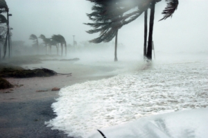
 While tornadoes tend to peak in the spring, there is no set “tornado season” like there is for hurricanes. The 2017 Atlantic hurricane season, which began yesterday, could bring “above-normal” storm activity. The National Oceanic and Atmospheric Administration’s (NOAA) outlook, released last week, predicts the development of 11 to 17 named storms, of which five to nine will reach hurricane status (greater than 74 mph) and two to four will become a major hurricane (Category 3 or higher) with winds in excess of 111 mph.
During 2016, Americans experienced 15 weather disasters costing more than $1 billion dollars each—the second highest number of events since 1980.
A prediction for an above-average season is based on the lack of El Nino conditions for the first time in several years. A strong El Nino typically suppresses tropical development in the Atlantic by inhibiting thunderstorm development.
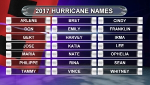
The 2017 hurricane season will span from June to November, but historically, around 85 percent of the action occurs in August, September and October. Hurricanes’ names are selected by the World Meteorological Organization. Every six years, the list of names begins again. However, the names of especially destructive hurricanes are usually retired.
Atlantic Tropical and Subtropical Storm Names for the 2017 Hurricane Season

This year, NOAA has introduced new observing, modeling, forecasting and communication tools to improve their hurricane warning capabilities.
A camera on NOAA’s new Geostationary Operational Environmental Satellite (GOES-16) will provide greater image resolution, sharp detail and a rapid-refresh rate. The satellite also has a lightning mapper which will allow forecasters to see lightning strikes that build within tropical cyclones, which is a sign of possible strengthening. At NOAA’s National Hurricane Center, forecasters will have the ability to issue Storm Surge Watches and Warnings operationally this year, in addition to issuing advisories, watches and warnings for disturbances that aren’t yet a tropical cyclone but still threaten land with tropical storm or hurricane conditions within 48 hours. The center added a new experimental visualization tool so the public can easily see when damaging winds are forecast to reach their community. Also, beginning this year, the public will be able to click on the hurricane track cone graphic and see how far outside of the cone hurricane and tropical-storm-force winds extend, which can be hundreds of miles.
The data sets from these instruments will be analyzed and compared to the data collected by planes, drones and ground sensors to validate and calibrate the instruments on the satellite. It is expected that GOES-16 data will be declared operational, approximately 6-12 months after launch, which occurred in November 2016.
SPI’s government contracting consultants have decades of experience and personal relationships at all levels of government. Learn how they can help your company grow your business by contacting them today.
